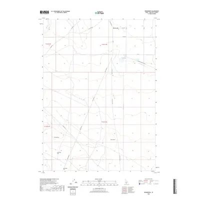
2020 Map of Roseworth
USGS Topo · Published 2020About this map
Roseworth and its surrounding high-desert terrain are defined by a sophisticated irrigation network that makes agricultural life possible in this corner of Twin Falls County. The 2020 landscape is dominated by the Cedar Mesa Reservoir and the arterial Cedar Mesa Canal, which feed smaller systems like A Lateral and Clark Lateral. This infrastructure transforms the arid stretches between the volcanic topography of Coonskin Butte and Pigtail Butte. The map reveals a history of land management through family-named geographic features, including John Boyd Flat, John Boyd Draw, and Worley Draw. Roads such as Big Bend Rd and House Creek Rd provide the primary transit through these section-line divisions, connecting isolated homesteads to the seasonal flow of Devil Cr.
Find a feature on this map
26 named features on this map. Tap any name to fly to it.
Don’t see what you’re looking for? This feature index may not catch every label — zoom into the map to look around manually.
Map Details
Editions of this 2020 Roseworth Map
This is the sole edition of this map. No revisions or reprints were ever made.
Other maps of this area

1955 · Twin Falls
USGS Topo · 1:250,000

1958 · Twin Falls
USGS Topo · 1:250,000

1964 · Roseworth
USGS Topo · 1:24,000

1965 · Roseworth SE
USGS Topo · 1:24,000

1965 · Roseworth NE
USGS Topo · 1:24,000

1965 · Tuanna Butte
USGS Topo · 1:24,000

1977 · Cedar Creek Reservoir
USGS Topo · 1:24,000

1978 · Browns Bench North
USGS Topo · 1:24,000

1979 · Coonskin Butte NE
USGS Topo · 1:24,000
1979 · Roseworth NE
USGS Topo · 1:24,000