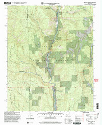
2002 Map of Rosilla Peak
USGS Topo · Published 2003About this map
The Pecos River valley carves through the heart of the Santa Fe National Forest in this 2002 revision, revealing a landscape defined by isolated ranching outposts and seasonal mountain retreats. The river corridor serves as the primary artery for local life, linking the Holy Ghost Summer Home Area and Terrero in the north to the tiered settlements of Upper La Posada and Lower La Posada further downstream. The map documents significant recreational and institutional footprints, including Brush Ranch, Camp La Salle, and Hidden Valley Ranch. Historical industrial activity is evidenced by scattered Mines in the high country west of Macho Canyon, while the archaeological site at El Macho (Site) marks an older chapter of habitation along the canyon floor. From the heights of Rosilla Peak to the drainages of Cow Creek, the map illustrates a rugged intersection of wilderness and remote habitation.
Find a feature on this map
32 named features on this map. Tap any name to fly to it.
Don’t see what you’re looking for? This feature index may not catch every label — zoom into the map to look around manually.
Map Details
Editions of this 2002 Rosilla Peak Map
This is the sole edition of this map. No revisions or reprints were ever made.
Other maps of this area

1889 · Santa Fe
USGS Topo · 1:125,000

1894 · Santa Fe
USGS Topo · 1:125,000

1953 · Glorieta
USGS Topo · 1:24,000

1953 · Mc Clure Reservoir
USGS Topo · 1:24,000

1953 · Aspen Basin
USGS Topo · 1:24,000

1954 · Santa Fe
USGS Topo · 1:250,000

1958 · Santa Fe
USGS Topo · 1:250,000

1961 · Honey Boy Ranch
USGS Topo · 1:24,000

1961 · Rosilla Peak
USGS Topo · 1:24,000
1961 · Pecos
USGS Topo · 1:24,000