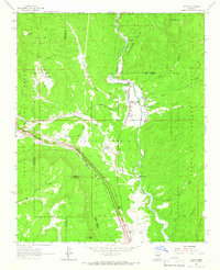
1961 Map of Pecos
USGS Topo · Published 1966About this map
The Pecos River carves a deep valley through this northern New Mexico landscape, dominated by the ancient cultural heritage at Pecos State Monument Ruins. This 1961 field-checked survey reveals a complex mix of religious, industrial, and recreational land use, from the Benedictine Monastery and the Lisboa Springs Fish Hatchery in Alexander Valle to the Fairview Lode Mine in the northwest. The presence of the Atchison Topeka and Santa Fe railroad line running parallel to Glorieta Creek underscores the region's historical importance as a transit corridor. Settlement patterns are concentrated in Pecos and East Pecos, while the surrounding Santa Fe National Forest is marked by steep canyons like Alamitos Canyon and the expansive heights of Rowe Peak. Traces of the cattle-ranching era are evident at the Forked Lightning Ranch near the Trading Post on the southern river bends.
Find a feature on this map
34 named features on this map. Tap any name to fly to it.
Don’t see what you’re looking for? This feature index may not catch every label — zoom into the map to look around manually.
Map Details
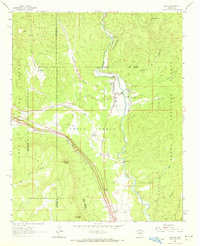
Editions of this 1961 Pecos Map
2 editions found
Other maps of this area

1889 · Santa Fe
USGS Topo · 1:125,000

1894 · Santa Fe
USGS Topo · 1:125,000

1894 · Lamy
USGS Topo · 1:125,000

1953 · Glorieta
USGS Topo · 1:24,000

1953 · Mc Clure Reservoir
USGS Topo · 1:24,000

1954 · Santa Fe
USGS Topo · 1:250,000

1958 · Santa Fe
USGS Topo · 1:250,000

1961 · Honey Boy Ranch
USGS Topo · 1:24,000

1961 · Rosilla Peak
USGS Topo · 1:24,000
1961 · Lower Colonias
USGS Topo · 1:24,000