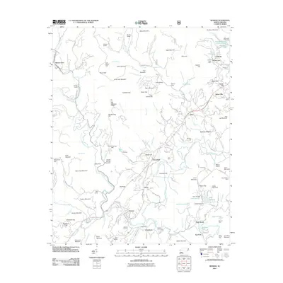
2011 Map of Rosman
USGS Topo · Published 2011About this map
The North Fork French Broad River and West Fork French Broad River converge near Rosman, a key junction point for water and transport in this Appalachian landscape. By the early 21st century, the area shows a distinct transition from the forested heights of Stone Mountain and Negro Mountain to the organized recreational and residential enclaves of Illahee Hills and Barberry Heights. The map reveals the historical roots of the region through family-named locations and burial sites like Whitmire Cemetery and Gillespie Cemetery. Numerous seasonal and youth camps, including Camp Illahee, Keystone Camp, and Kaiser Lake Camp Cherryfield, reflect a long-standing regional economy rooted in summer tourism and outdoor education. Infrastructure is marked by several water control features such as the Lake Wanteska Dam and Ford Lake Dam, while small settlements like Balsam Grove and Powelltown remain central to the local geography.
Find a feature on this map
189 named features on this map. Tap any name to fly to it.
Don’t see what you’re looking for? This feature index may not catch every label — zoom into the map to look around manually.
Map Details
Editions of this 2011 Rosman Map
This is the sole edition of this map. No revisions or reprints were ever made.
Other maps of this area

1905 · Pisgah
USGS Topo · 1:125,000

1906 · Pisgah
USGS Topo · 1:125,000

1935 · Brevard
USGS Topo · 1:24,000

1935 · Eastatoe Gap
USGS Topo · 1:24,000

1935 · Sam Knob
USGS Topo · 1:24,000

1935 · Rosman
USGS Topo · 1:24,000

1935 · Lake Toxaway
USGS Topo · 1:24,000

1935 · Reid
USGS Topo · 1:24,000

1935 · Table Rock
USGS Topo · 1:24,000

1935 · Shining Rock
USGS Topo · 1:24,000