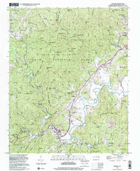
1997 Map of Rosman
USGS Topo · Published 2001About this map
Pisgah National Forest and the upper reaches of the French Broad River dominate this landscape, where mountain ridges and valleys define the local geography. The settlement of Rosman serves as a central hub, flanked by smaller communities like Balsam Grove and Powelltown. This 1997 photo-inspection reveals a mix of institutional and recreational land use, including the NASA Tracking Station and the State Prison Camp. Family and community history is anchored in landmarks like the Shady Grove Cem, Whitmire Cem, and Zion Ch. The presence of numerous camps, such as Camp Illahee and Keystone Camp, suggests a long-standing tradition of summer retreats nestled within the Brushy Ridge and Big Mountain Ridge foothills. The terrain is marked by gaps and coves, like Low Notch Gap and Daves Cove, which have long dictated the path of local travel and settlement.
Find a feature on this map
136 named features on this map. Tap any name to fly to it.
Don’t see what you’re looking for? This feature index may not catch every label — zoom into the map to look around manually.
Map Details
Editions of this 1997 Rosman Map
This is the sole edition of this map. No revisions or reprints were ever made.
Other maps of this area

1905 · Pisgah
USGS Topo · 1:125,000

1906 · Pisgah
USGS Topo · 1:125,000

1935 · Brevard
USGS Topo · 1:24,000

1935 · Eastatoe Gap
USGS Topo · 1:24,000

1935 · Sam Knob
USGS Topo · 1:24,000
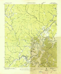
1935 · Rosman
USGS Topo · 1:24,000

1935 · Lake Toxaway
USGS Topo · 1:24,000

1935 · Reid
USGS Topo · 1:24,000

1935 · Table Rock
USGS Topo · 1:24,000

1935 · Shining Rock
USGS Topo · 1:24,000