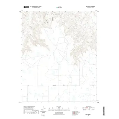
2019 Map of Ross Canyon
USGS Topo · Published 2019About this map
Ross Canyon dominates the northwestern portion of this Briscoe County landscape, where the dramatic elevation changes of the Caprock Escarpment are clearly visible. The terrain is deeply incised by McMurtry Canyon and Lufberg Canyon, which feed toward the drainage of Tule Cr. This area represents a classic West Texas transition where the flat, high plains of the Llano Estacado give way to the broken canyonlands below. Below the rim, the land opens into a more accessible terrain marked by intermittent watercourses like Coon Cr. The road network, including Ranch Rd 3030 and various county routes such as Co RD 12 and Co RD 13, traces the section lines of the high plains, providing essential access to the remote ranching operations that define the local economy.
Find a feature on this map
18 named features on this map. Tap any name to fly to it.
Don’t see what you’re looking for? This feature index may not catch every label — zoom into the map to look around manually.
Map Details
Editions of this 2019 Ross Canyon Map
This is the sole edition of this map. No revisions or reprints were ever made.
Other maps of this area

1954 · Plainview
USGS Topo · 1:250,000

1958 · Plainview
USGS Topo · 1:250,000

1960 · Indian Peak
USGS Topo · 1:62,500

1965 · Ross Canyon
USGS Topo · 1:24,000

1965 · Big Betty Reservoir
USGS Topo · 1:24,000

1965 · Silverton
USGS Topo · 1:24,000

1965 · Rock Creek
USGS Topo · 1:24,000

1965 · Vigo Park
USGS Topo · 1:24,000

1965 · Cope Creek
USGS Topo · 1:24,000

1967 · Hay Lake
USGS Topo · 1:24,000