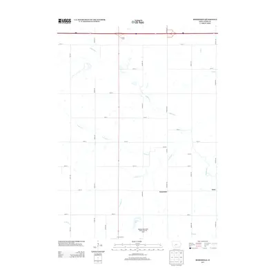
2013 Map of Rosserdale
USGS Topo · Published 2013About this map
The agrarian landscape of Adair County is defined here by the winding course of the Middle River and several drainage creeks including N Turkey Cr and S Turkey Cr. The small community of Rosserdale is situated near the center of the grid-patterned road system, while Howe sits further east along Riverside Ave. This rural territory preserves traditional local identifiers such as School Number 4, marking the historical importance of localized education districts in Iowa's township structure. Conservation and recreation areas are prominent in the southern portion of the sheet, specifically the Meadow Lake State Public Hunting Area surrounding Meadow Lake. Transport and leisure are represented by the northern corridor of Interstate 80 and the 5 x 80 Golf Course, showing how modern infrastructure and local recreation have integrated into the long-standing agricultural framework of the region.
Find a feature on this map
30 named features on this map. Tap any name to fly to it.
Don’t see what you’re looking for? This feature index may not catch every label — zoom into the map to look around manually.
Map Details
Editions of this 2013 Rosserdale Map
This is the sole edition of this map. No revisions or reprints were ever made.
Other maps of this area

1952 · Panora
USGS Topo · 1:62,500

1954 · Greenfield
USGS Topo · 1:62,500

1954 · Omaha
USGS Topo · 1:250,000

1957 · Omaha
USGS Topo · 1:250,000

1958 · Omaha
USGS Topo · 1:250,000

1971 · Fontanelle
USGS Topo · 1:24,000

1971 · Canby
USGS Topo · 1:24,000

1971 · Casey
USGS Topo · 1:24,000
1982 · Stuart North
USGS Topo · 1:24,000
1982 · Menlo
USGS Topo · 1:24,000