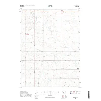
2018 Map of Rosserdale
USGS Topo · Published 2018About this map
Middle River and its numerous tributaries, including N Turkey Cr and S Turkey Cr, carve a complex drainage pattern across this section of Adair County. The landscape is defined by its agricultural grid, yet it retains significant markers of early settlement history through its many burial sites. Genealogists will find several distinct locations, ranging from the Abandoned Timber Cem in the northwest to the Grove Center Cem in the south. The small communities of Rosserdale and Howe serve as local anchors along the secondary road network, connected by routes like Co RD g27. While the northern edge is clipped by a major expressway, the interior remains focused on the creek valleys and the ridges between North River and the Tuskegee drainage, reflecting a rural Iowa landscape largely unchanged in its fundamental layout since the early twentieth century.
Find a feature on this map
34 named features on this map. Tap any name to fly to it.
Don’t see what you’re looking for? This feature index may not catch every label — zoom into the map to look around manually.
Map Details
Editions of this 2018 Rosserdale Map
This is the sole edition of this map. No revisions or reprints were ever made.
Other maps of this area

1952 · Panora
USGS Topo · 1:62,500

1954 · Greenfield
USGS Topo · 1:62,500

1954 · Omaha
USGS Topo · 1:250,000

1957 · Omaha
USGS Topo · 1:250,000

1958 · Omaha
USGS Topo · 1:250,000

1971 · Fontanelle
USGS Topo · 1:24,000

1971 · Canby
USGS Topo · 1:24,000

1971 · Casey
USGS Topo · 1:24,000
1982 · Stuart North
USGS Topo · 1:24,000
1982 · Menlo
USGS Topo · 1:24,000