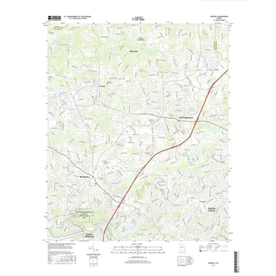
2017 Map of Roswell
USGS Topo · Published 2017About this map
The Chattahoochee River corridor anchors this modern topographic look at the rapidly evolving North Fulton landscape. The Chattahoochee River National Recreation Area preserves the riverbank south of Roswell and Sandy Springs, while the upland area reveals a dense network of suburban development surrounding the older centers of Alpharetta, Milton, and Crabapple. Genealogists will find a high concentration of burial grounds, from the large Green Lawn Cem and Mausoleum to smaller family and church sites like Martin Cem, Maxwell Cem, and the Crabapple Baptist Cem. These sites, along with the Founder Cem near the river, offer a clear trace of the area's original agrarian settlement patterns before it became a major suburban hub. Smaller waterways like Big Creek and Foe Killer Creek provide a drainage network through these developing neighborhoods, occasionally pooling into local landmarks such as Martin Lake or Vinson Lake.
Find a feature on this map
306 named features on this map. Tap any name to fly to it.
Don’t see what you’re looking for? This feature index may not catch every label — zoom into the map to look around manually.
Map Details
Editions of this 2017 Roswell Map
This is the sole edition of this map. No revisions or reprints were ever made.
Other maps of this area

1888 · Atlanta
USGS Topo · 1:125,000

1890 · Suwanee
USGS Topo · 1:125,000

1890 · Atlanta
USGS Topo · 1:125,000

1892 · Atlanta
USGS Topo · 1:125,000

1894 · Suwanee
USGS Topo · 1:125,000

1895 · Atlanta
USGS Topo · 1:125,000

1953 · Atlanta
USGS Topo · 1:250,000

1954 · Chamblee
USGS Topo · 1:24,000

1955 · Rome
USGS Topo · 1:250,000
1955 · Sandy Springs
USGS Topo · 1:24,000