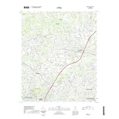
2020 Map of Roswell
USGS Topo · Published 2020About this map
Alpharetta and Roswell anchor this contemporary mapping of northern Fulton County, showing the suburban evolution of historically distinct communities like Crabapple and Fields Crossroads. The landscape is a mix of dense residential development and protected corridors, most notably the Chattahoochee River National Recreation Area which defines the southern and eastern margins of the sheet. For those tracing local heritage, the map is a remarkable record of preservation, marking numerous historic burial sites such as Old Big Creek Cem, Hembree Cem, and the Founder Cem tucked among modern infrastructure. The hydrology of the region is well-documented, with the Chattahoochee River fed by systems like Big Cr and Foe Killer Cr, while small impoundments like Lake Arrida and Bartenfield Lake dot the residential landscape.
Find a feature on this map
391 named features on this map. Tap any name to fly to it.
Don’t see what you’re looking for? This feature index may not catch every label — zoom into the map to look around manually.
Map Details
Editions of this 2020 Roswell Map
This is the sole edition of this map. No revisions or reprints were ever made.
Other maps of this area

1888 · Atlanta
USGS Topo · 1:125,000

1890 · Suwanee
USGS Topo · 1:125,000

1890 · Atlanta
USGS Topo · 1:125,000

1892 · Atlanta
USGS Topo · 1:125,000

1894 · Suwanee
USGS Topo · 1:125,000

1895 · Atlanta
USGS Topo · 1:125,000

1953 · Atlanta
USGS Topo · 1:250,000

1954 · Chamblee
USGS Topo · 1:24,000

1955 · Rome
USGS Topo · 1:250,000
1955 · Sandy Springs
USGS Topo · 1:24,000