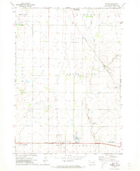
1972 Map of Roswell
USGS Topo · Published 1973About this map
Roswell and Argonne anchor this early 1970s view of the rural landscape in Miner County, where the agricultural grid is defined by historical township boundaries like Green Valley and Clinton. The map reveals a transition in regional transportation, showing the Chicago and North Western railroad cutting diagonally across the northeastern corner, while the Chicago Milwaukee St Paul and Pacific line runs east-west through the southern portion. This intersection of rail lines highlights the area's importance as a shipping point for local produce. Along the winding course of Rock Creek, several tracts are designated as National Wildlife Management Area, preserving pockets of the original prairie environment amidst the systematic section lines of the Carthage and Redstone districts. The detailed inclusion of fence and field lines provides a unique look at land use and property divisions of the era.
Find a feature on this map
16 named features on this map. Tap any name to fly to it.
Don’t see what you’re looking for? This feature index may not catch every label — zoom into the map to look around manually.
Map Details
Editions of this 1972 Roswell Map
This is the sole edition of this map. No revisions or reprints were ever made.
Other maps of this area

1899 · Alexandria
USGS Topo · 1:125,000

1899 · De Smet
USGS Topo · 1:125,000

1953 · Watertown
USGS Topo · 1:250,000

1955 · Sioux Falls
USGS Topo · 1:250,000

1958 · Sioux Falls
USGS Topo · 1:250,000

1958 · Watertown
USGS Topo · 1:250,000

1971 · Howard NE
USGS Topo · 1:24,000

1971 · Fedora
USGS Topo · 1:24,000

1971 · Artesian NE
USGS Topo · 1:24,000

1971 · Howard
USGS Topo · 1:24,000