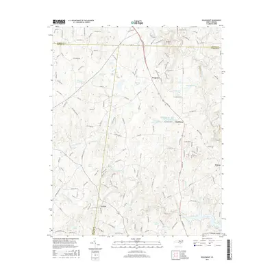
2016 Map of Rougemont
USGS Topo · Published 2016About this map
Rougemont sits at the intersection of the county lines between Person, Orange, and Durham, serving as a focal point for this landscape defined by the upper reaches of the Flat River and Little River systems. The map illustrates a network of rural roads such as Roxboro Rd and Durham Rd that connect smaller communities like Bahama and Quail Roost. The area is dotted with numerous small impoundments and ponds, including Gantt Lake, Caldmont Lake, and McFarland Lake, which highlight the importance of water management in this Piedmont terrain.
Find a feature on this map
142 named features on this map. Tap any name to fly to it.
Don’t see what you’re looking for? This feature index may not catch every label — zoom into the map to look around manually.
Map Details
Editions of this 2016 Rougemont Map
This is the sole edition of this map. No revisions or reprints were ever made.
Other maps of this area

1943 · Roxboro
USGS Topo · 1:62,500

1951 · Durham North
USGS Topo · 1:62,500

1953 · Greensboro
USGS Topo · 1:250,000

1954 · Greensboro
USGS Topo · 1:250,000

1962 · Greensboro
USGS Topo · 1:250,000

1966 · Greensboro
USGS Topo · 1:250,000
1968 · Hillsborough
USGS Topo · 1:24,000

1968 · Caldwell
USGS Topo · 1:24,000

1968 · Hurdle Mills
USGS Topo · 1:24,000
1973 · Northeast Durham
USGS Topo · 1:24,000