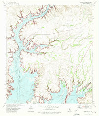
1972 Map of Rough Canyon
USGS Topo · Published 1975About this map
Amistad Reservoir dominates this landscape in the early 1970s, where the rising waters of the Rio Grande basin have transformed the arid canyons of Val Verde County. The map documents the development of the National Recreation Area, showing how the impoundment reached into the steep-walled Rough Canyon and the winding course of the Devils River. Human activity at this time is centered on recreation and burgeoning lakeside settlements, as seen at Devils Shores and the infrastructure around the Rough Canyon Marina. High-water marks like Elevation 1114 and Elevation 1117 indicate the shifting shoreline and submerged terrain. Away from the water, Recreational Road No 2 provides access through the high limestone plateaus, connecting the shoreline to the interior of the Texas borderlands.
Find a feature on this map
12 named features on this map. Tap any name to fly to it.
Don’t see what you’re looking for? This feature index may not catch every label — zoom into the map to look around manually.
Map Details
Editions of this 1972 Rough Canyon Map
This is the sole edition of this map. No revisions or reprints were ever made.
Other maps of this area

1941 · Feely
USGS Topo · 1:62,500

1943 · Devils River
USGS Topo · 1:62,500

1943 · Del Rio
USGS Topo · 1:62,500

1944 · Devils River
USGS Topo · 1:62,500

1944 · Devils Lake
USGS Topo · 1:62,500

1958 · Del Rio
USGS Topo · 1:250,000

1964 · Del Rio
USGS Topo · 1:250,000

1972 · Amistad Dam
USGS Topo · 1:24,000

1972 · California Creek
USGS Topo · 1:24,000

1972 · Miers Ranch
USGS Topo · 1:24,000