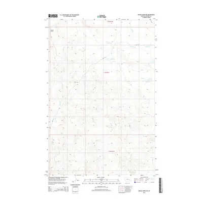
2014 Map of Rough Creek NE
USGS Topo · Published 2014About this map
Upper Coal Cr and its many offshooting drainages carve through this section of Rosebud County, showing a complex network of intermittent watercourses that define the local topography. This 2014 survey by the U.S. Geological Survey details a landscape shaped by erosion, with features like Wildcat Coulee in the northwest corner and the significant Trail Cr Reservoir central to the eastern half. The map traces the winding paths of Ryans Fork and S Sunday Cr, illustrating the watershed patterns typical of this Montana region. Human impact is sparse, represented primarily by rural routes such as Road 203 and Road 205 which navigate the high ground between creek beds like Coal Cr and Rough Cr. This map is particularly useful for understanding the exact drainage boundaries and land divisions within townships t11n r41e, t12n r41e, and t10n r41e.
Find a feature on this map
14 named features on this map. Tap any name to fly to it.
Don’t see what you’re looking for? This feature index may not catch every label — zoom into the map to look around manually.
Map Details
Editions of this 2014 Rough Creek NE Map
This is the sole edition of this map. No revisions or reprints were ever made.
Other maps of this area

1954 · Forsyth
USGS Topo · 1:250,000

1957 · Forsyth
USGS Topo · 1:250,000

1958 · Forsyth
USGS Topo · 1:250,000

1965 · Needle Butte Reservoir
USGS Topo · 1:24,000

1965 · Needle Butte
USGS Topo · 1:24,000

1965 · Clear Water Reservoir
USGS Topo · 1:24,000

1969 · Van Burton Creek
USGS Topo · 1:24,000

1969 · Rudie Coulee
USGS Topo · 1:24,000

1969 · Wild Horse Pass
USGS Topo · 1:24,000
1969 · Rough Creek SE
USGS Topo · 1:24,000