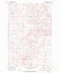
1969 Map of Rough Creek SE
USGS Topo · Published 1973About this map
Gray Ranch serves as a lonely landmark in this high-plains landscape of eastern Montana, where the terrain is defined by an intricate network of drainage systems. At the time of this 1969 field check, the area remained deeply rural, with limited human infrastructure beyond scattered water wells and a few unimproved ranch roads. The hydrology is dominated by seasonal watercourses like Pork Creek and the North Fork Cottonwood Creek in the north, while the southern reaches are fed by Wolf Creek and the East Fork Horse Creek. These water sources were essential for the cattle operations that shaped the local economy and land use. The map reveals the slow rhythm of life in Rosebud County, where the topography of the draws and coulees dictated the placement of every fence line and livestock watering hole.
Find a feature on this map
7 named features on this map. Tap any name to fly to it.
Don’t see what you’re looking for? This feature index may not catch every label — zoom into the map to look around manually.
Map Details
Editions of this 1969 Rough Creek SE Map
This is the sole edition of this map. No revisions or reprints were ever made.
Other maps of this area

1954 · Forsyth
USGS Topo · 1:250,000

1957 · Forsyth
USGS Topo · 1:250,000

1958 · Forsyth
USGS Topo · 1:250,000

1968 · Box Canyon Coulee
USGS Topo · 1:24,000

1968 · Schultz Coulee
USGS Topo · 1:24,000

1968 · Black Coulee
USGS Topo · 1:24,000

1969 · Van Burton Creek
USGS Topo · 1:24,000

1969 · Rudie Coulee
USGS Topo · 1:24,000

1969 · Wild Horse Pass
USGS Topo · 1:24,000
1969 · Rough Creek SW
USGS Topo · 1:24,000