
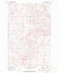
1968 Map of Schultz Coulee
USGS Topo · Published 1972About this map
Schultz Coulee and its surrounding drainages in Rosebud County define this landscape as it was documented in the late 1960s. The terrain is a complex network of seasonal watercourses and ridges, anchored by distinctive landforms like Ice Cream Butte and the Black Buttes. Water management is central to the area's geography, evidenced by the Big Reservoir and East Fork Reservoir, which serve as vital points in an otherwise arid environment.
Find a feature on this map
15 named features on this map. Tap any name to fly to it.
Don’t see what you’re looking for? This feature index may not catch every label — zoom into the map to look around manually.
Map Details
Editions of this 1968 Schultz Coulee Map
This is the sole edition of this map. No revisions or reprints were ever made.
Other maps of this area

1954 · Forsyth
USGS Topo · 1:250,000

1957 · Forsyth
USGS Topo · 1:250,000

1958 · Forsyth
USGS Topo · 1:250,000

1968 · Orinoco
USGS Topo · 1:24,000

1968 · Rosebud
USGS Topo · 1:24,000

1968 · Box Canyon Coulee
USGS Topo · 1:24,000

1968 · Forsyth
USGS Topo · 1:24,000

1968 · Black Coulee
USGS Topo · 1:24,000

1969 · Wild Horse Pass
USGS Topo · 1:24,000
1969 · Rough Creek SE
USGS Topo · 1:24,000