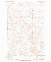
1969 Map of Rough Creek NE
USGS Topo · Published 1973About this map
Upper Coal Creek and South Sunday Creek carve through this Rosebud County landscape, revealing a pattern of drainage and terrain typical of eastern Montana in the late 1960s. The area is defined by its water management and sparse transport network, centered around the Trail Creek Reservoir and the winding course of Trail Creek. This 1969 field-checked survey captures the region just before significant modern changes, where access was largely restricted to a Jeep Trail and unnamed secondary roads. Notable landforms like Wildcat Coulee and the headwaters of Rough Creek illustrate the natural erosion patterns of the high plains, providing a clear record of the watershed before intensive contemporary development or land use changes altered these drainages.
Find a feature on this map
8 named features on this map. Tap any name to fly to it.
Don’t see what you’re looking for? This feature index may not catch every label — zoom into the map to look around manually.
Map Details
Editions of this 1969 Rough Creek NE Map
This is the sole edition of this map. No revisions or reprints were ever made.
Other maps of this area

1954 · Forsyth
USGS Topo · 1:250,000

1957 · Forsyth
USGS Topo · 1:250,000

1958 · Forsyth
USGS Topo · 1:250,000

1965 · Needle Butte Reservoir
USGS Topo · 1:24,000

1965 · Needle Butte
USGS Topo · 1:24,000

1965 · Clear Water Reservoir
USGS Topo · 1:24,000

1969 · Van Burton Creek
USGS Topo · 1:24,000

1969 · Rudie Coulee
USGS Topo · 1:24,000

1969 · Wild Horse Pass
USGS Topo · 1:24,000
1969 · Rough Creek SE
USGS Topo · 1:24,000