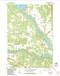
1983 Map of Round Bluff
USGS Topo · Published 1984About this map
The confluence of the Wisconsin River and the Lemonweir River dominates this 1980s landscape, illustrating a complex network of wetlands and river channels south of Castle Rock Lake. This survey captures a moment when traditional land uses like the townhall and St Michaels Cem in Marion persisted alongside the burgeoning recreational character of the region. The map details a transition from the agricultural grid to the specialized grounds of the Woodside Ranch and the extensive bridle trails that weave through the woodlands north of the Lemonweir River. To the south, the Chicago Milwaukee St Paul and Pacific railroad cuts through the terrain near the distinct elevation of Round Bluff, while the settlements of Germantown and Springville sit on opposite banks of the primary river system.
Find a feature on this map
48 named features on this map. Tap any name to fly to it.
Don’t see what you’re looking for? This feature index may not catch every label — zoom into the map to look around manually.
Map Details
Editions of this 1983 Round Bluff Map
This is the sole edition of this map. No revisions or reprints were ever made.
Other maps of this area

1901 · The Dells
USGS Topo · 1:62,500

1921 · Mauston
USGS Topo · 1:62,500

1956 · Reedsburg
USGS Topo · 1:62,500

1957 · Wisconsin Dells
USGS Topo · 1:62,500

1957 · Madison
USGS Topo · 1:250,000

1958 · La Crosse
USGS Topo · 1:250,000

1960 · Madison
USGS Topo · 1:250,000

1961 · La Crosse
USGS Topo · 1:250,000

1961 · Adams
USGS Topo · 1:62,500

1962 · Mauston
USGS Topo · 1:62,500