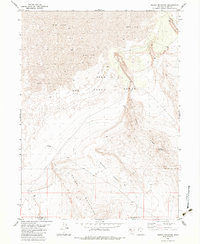
1983 Map of Round Mountain
USGS Topo · Published 1983About this map
Hill Force Range dominates this corner of the Great Salt Lake Desert, where the stark topography of the Grassy Mountains meets the expansive Mud Flat. This 1983 edition, based on earlier aerial photography, delineates the remote border between Box Elder Co and Tooele Co. The terrain is characterized by sharp elevation changes, particularly along the Ridge leading to the summit of Round Mountain. Infrastructure in this arid environment is sparse but telling, featuring an Observation Tower and a isolated Well located within German Valley. Industrial activity is marked by Gravel Pits and a Gravel Pit at the base of the mountains, while a solitary Tank stands as a landmark amidst the high desert brush. The mapping reflects a landscape shaped primarily by military and resource extraction needs rather than residential settlement.
Find a feature on this map
14 named features on this map. Tap any name to fly to it.
Don’t see what you’re looking for? This feature index may not catch every label — zoom into the map to look around manually.
Map Details
Editions of this 1983 Round Mountain Map
This is the sole edition of this map. No revisions or reprints were ever made.
Other maps of this area

1885 · Tooele Valley
USGS Topo · 1:250,000

1953 · Tooele
USGS Topo · 1:250,000

1954 · Brigham City
USGS Topo · 1:250,000

1955 · Tooele
USGS Topo · 1:250,000

1958 · Brigham City
USGS Topo · 1:250,000

1962 · Brigham City
USGS Topo · 1:250,000

1969 · Hogup Ridge South
USGS Topo · 1:24,000

1969 · Strongs Knob
USGS Topo · 1:24,000

1973 · Grassy Mountains
USGS Topo · 1:24,000

1973 · Finger Ridge
USGS Topo · 1:24,000