
1973 Map of Finger Ridge
USGS Topo · Published 1977About this map
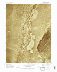
Hill Air Force Range dominates this mid-1970s orthophotomap, where the desolate landscape of the Great Salt Lake Desert was utilized for military operations. The terrain is characterized by the expansive Mud Flat, a featureless expanse of alkali and silt that shifts into the distinctive topography of Finger Ridge to the east. This specialized map format, an orthophotomosaic, uses 1972 aerial photography to provide a realistic visual representation of the ground surface, revealing the intricate patterns of the Hill formations and the stark boundary between Box Elder Co and Tooele Co. Areas marked as Restricted underscore the sensitive nature of this high-desert testing ground during the Cold War era, providing a rare look at the footprint of national defense infrastructure within Utah’s wilderness.
Find a feature on this map
6 named features on this map. Tap any name to fly to it.
Don’t see what you’re looking for? This feature index may not catch every label — zoom into the map to look around manually.
Map Details
Editions of this 1973 Finger Ridge Map
2 editions found
Other maps of this area

1953 · Tooele
USGS Topo · 1:250,000

1954 · Brigham City
USGS Topo · 1:250,000

1955 · Tooele
USGS Topo · 1:250,000

1958 · Brigham City
USGS Topo · 1:250,000

1962 · Brigham City
USGS Topo · 1:250,000

1973 · Ripple Valley
USGS Topo · 1:24,000

1973 · Grassy Mountains
USGS Topo · 1:24,000

1973 · Knolls 2 NE
USGS Topo · 1:24,000

1973 · Grayback Hills
USGS Topo · 1:24,000
1973 · North of Knolls
USGS Topo · 1:24,000