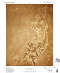
1973 Map of North of Knolls
USGS Topo · Published 1995About this map
Utah Test and Training Range North dominates this landscape in western Tooele County, captured here as an orthophotomap during the early 1970s. The sheet provides a literal visual record of the vast Mud Flat and the complex salt crust patterns of the Great Salt Lake Desert. Unlike traditional line-drawn maps, this mosaic uses aerial photography to show the nuanced textures of the desert floor, where the Military Reservation Boundary cuts a geometric line across the organic, swirling geological deposits. This specific region, located north of the Knolls area, is defined by the intersection of the Base Line and the extensive federal military grounds, illustrating a remote corridor of the American West dedicated to aerospace and defense testing.
Find a feature on this map
5 named features on this map. Tap any name to fly to it.
Don’t see what you’re looking for? This feature index may not catch every label — zoom into the map to look around manually.
Map Details
Editions of this 1973 North of Knolls Map
This is the sole edition of this map. No revisions or reprints were ever made.
Other maps of this area

1953 · Tooele
USGS Topo · 1:250,000

1955 · Tooele
USGS Topo · 1:250,000

1973 · Knolls 2 NW
USGS Topo · 1:24,000

1973 · Knolls 2 NE
USGS Topo · 1:24,000

1973 · Knolls
USGS Topo · 1:24,000

1973 · Aragonite NW
USGS Topo · 1:24,000

1973 · Barro
USGS Topo · 1:24,000

1973 · Grayback Hills
USGS Topo · 1:24,000

1973 · Finger Ridge
USGS Topo · 1:24,000

1973 · Knolls 2 SW
USGS Topo · 1:24,000