
1973 Map of Knolls 2 NE
USGS Topo · Published 1977About this map
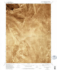
Hill Air Force Range dominates this orthophotomap, showing the stark intersection of military infrastructure and the extreme terrain of the Great Salt Lake Desert in the early 1970s. The landscape is characterized by extensive Mud Flat areas that surround the southern reaches of the Newfoundland Mountains. This survey, created from 1972 aerial photography, uses a photographic base to reveal the subtle textures of the salt flats and the sharp relief of the desert ranges. The boundary between Box Elder Co and Tooele Co cuts across the northern section, marking a remote administrative divide in a region defined by its isolation and use as a military testing and training ground. The intricate drainage patterns and salt crusts visible on the Mud Flat provide a clear view of the hydrological character of the basin before later seasonal changes.
Find a feature on this map
4 named features on this map. Tap any name to fly to it.
Don’t see what you’re looking for? This feature index may not catch every label — zoom into the map to look around manually.
Map Details
Editions of this 1973 Knolls 2 NE Map
2 editions found
Other maps of this area

1953 · Tooele
USGS Topo · 1:250,000

1954 · Brigham City
USGS Topo · 1:250,000

1955 · Tooele
USGS Topo · 1:250,000

1958 · Brigham City
USGS Topo · 1:250,000

1962 · Brigham City
USGS Topo · 1:250,000

1973 · Knolls 2 NW
USGS Topo · 1:24,000

1973 · Grayback Hills
USGS Topo · 1:24,000

1973 · Finger Ridge
USGS Topo · 1:24,000

1973 · Knolls 2 SW
USGS Topo · 1:24,000
1973 · North of Knolls
USGS Topo · 1:24,000