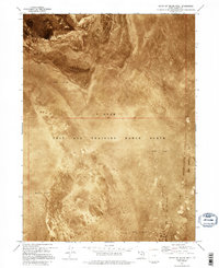
1973 Map of South of Keller Well
USGS Topo · Published 1995About this map
The Newfoundland Mountains rise abruptly from a landscape dominated by a massive Mud Flat in this remote stretch of the Great Salt Lake Desert. This orthophotomap, based on 1972 aerial photography, documents the stark interface between the salt crust and the rugged mountain terrain along the boundary of Box Elder Co and Tooele Co. Most of the region is occupied by the Utah Test and Training Range North, a vast military exclusion area. The imagery highlights the unique environmental character of the West Desert, where the extreme flatness of the playa is punctuated only by the complex topography of the mountains. Researchers of Western military history or desert geomorphology will find the detailed aerial perspective of this restricted zone particularly useful for understanding the scale and isolation of the training grounds.
Find a feature on this map
4 named features on this map. Tap any name to fly to it.
Don’t see what you’re looking for? This feature index may not catch every label — zoom into the map to look around manually.
Map Details
Editions of this 1973 South of Keller Well Map
2 editions found
Other maps of this area

1953 · Tooele
USGS Topo · 1:250,000

1954 · Brigham City
USGS Topo · 1:250,000

1955 · Tooele
USGS Topo · 1:250,000

1958 · Brigham City
USGS Topo · 1:250,000

1962 · Brigham City
USGS Topo · 1:250,000

1973 · Knolls 2 NW
USGS Topo · 1:24,000

1973 · Knolls 2 NE
USGS Topo · 1:24,000

1973 · Grayback Hills
USGS Topo · 1:24,000

1973 · Finger Ridge
USGS Topo · 1:24,000

1973 · Knolls 2 SW
USGS Topo · 1:24,000