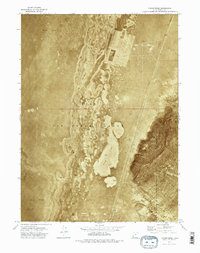
1973 Map of Finger Ridge
USGS Topo · Published 1977About this map
Hill Air Force Range dominates this landscape in the early 1970s, serving as a restricted military testing and training ground within the Great Salt Lake Desert. This orthophotomap provides a photographic record of the stark terrain, where the arid expanse of Mud Flat meets the distinct elevation of Finger Ridge to the east. The map captures the boundary between Box Elder Co and Tooele Co, illustrating how administrative lines were drawn across this desolate environment. The visible surface patterns in the orthophotomosaic reveal the complex network of salt crusts and seasonal water drainage that define the basin floor, providing a unique visual perspective of a region largely inaccessible to the public due to its Restricted status.
Find a feature on this map
5 named features on this map. Tap any name to fly to it.
Don’t see what you’re looking for? This feature index may not catch every label — zoom into the map to look around manually.
Map Details
Editions of this 1973 Finger Ridge Map
2 editions found
Other maps of this area

1953 · Tooele
USGS Topo · 1:250,000

1954 · Brigham City
USGS Topo · 1:250,000

1955 · Tooele
USGS Topo · 1:250,000

1958 · Brigham City
USGS Topo · 1:250,000

1962 · Brigham City
USGS Topo · 1:250,000

1973 · Ripple Valley
USGS Topo · 1:24,000

1973 · Grassy Mountains
USGS Topo · 1:24,000

1973 · Knolls 2 NE
USGS Topo · 1:24,000

1973 · Grayback Hills
USGS Topo · 1:24,000

1973 · Finger Ridge
USGS Topo · 1:24,000