
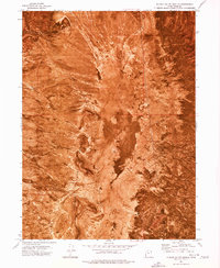
1973 Map of Ripple Valley
USGS Topo · Published 1977About this map
Grassy Mountains define the eastern edge of this 1973 orthophotomap, overlooking the wide expanse of Ripple Valley in Tooele County. Unlike standard topographic sheets, this orthophotomosaic provides a direct photographic record of the arid landscape, revealing the sparse vegetation and complex drainage patterns that lead toward the valley floor. Human activity is represented primarily by essential water sources and infrastructure, such as Thumb Well in the north and Swan Well further south. The map documents the intersection of the Base Line with township and range boundaries, providing a clear view of the surveying grid laid over the desert. Significant landmarks for desert navigation and resource extraction include a Borrow Pit and several View Point locations along the slopes of the mountains, which offer sightlines across the Great Salt Lake Desert region.
Find a feature on this map
13 named features on this map. Tap any name to fly to it.
Don’t see what you’re looking for? This feature index may not catch every label — zoom into the map to look around manually.
Map Details
Editions of this 1973 Ripple Valley Map
This is the sole edition of this map. No revisions or reprints were ever made.
Other maps of this area

1885 · Tooele Valley
USGS Topo · 1:250,000

1953 · Tooele
USGS Topo · 1:250,000

1955 · Tooele
USGS Topo · 1:250,000

1973 · Grassy Mountains
USGS Topo · 1:24,000

1973 · Low
USGS Topo · 1:24,000

1973 · Aragonite NW
USGS Topo · 1:24,000

1973 · Grayback Hills
USGS Topo · 1:24,000

1973 · Finger Ridge
USGS Topo · 1:24,000

1973 · Hastings Pass
USGS Topo · 1:24,000
1973 · Puddle Valley Knolls
USGS Topo · 1:24,000