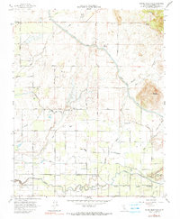
1964 Map of Round Mountain
USGS Topo · Published 1990About this map
Round Mountain rises above a landscape defined by an extensive network of irrigation and transport in this 1960s study of eastern Fresno County. The terrain transitions from the foothills down to the valley floor, where the Friant Kern Canal and Fresno Canal feed a grid of agricultural settlements and family holdings. Significant land use is marked by the presence of Baird Ranch in the north and Sunland Ranch further south, alongside established community sites like the Redbank Cem and the Fairmont Union Sch. The southern portion of the sheet is dominated by the Atchison Topeka and Santa Fe railroad line, which connects several small communities including Zediker and Riverbend as it parallels the Fancher Creek drainage. The map preserves a moment when the transition between ranching and more intensive irrigated farming was firmly established in the Central Valley.
Find a feature on this map
49 named features on this map. Tap any name to fly to it.
Don’t see what you’re looking for? This feature index may not catch every label — zoom into the map to look around manually.
Map Details
Editions of this 1964 Round Mountain Map
4 editions found
Other maps of this area

1920 · Orangedale School
USGS Topo · 1:24,000

1922 · Round Mountain
USGS Topo · 1:31,680

1922 · Trimmer
USGS Topo · 1:96,000

1922 · Friant
USGS Topo · 1:31,680

1923 · Malaga
USGS Topo · 1:31,680

1923 · Academy
USGS Topo · 1:31,680

1923 · Orangedale School
USGS Topo · 1:31,680

1923 · Clovis
USGS Topo · 1:31,680

1923 · Wahtoke
USGS Topo · 1:31,680

1923 · Sanger
USGS Topo · 1:31,680