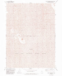
1991 Map of Round Mountain NW
USGS Topo · Published 1991About this map
Utah Test and Training Range North dominates this landscape, showing the austere geography of the Great Salt Lake Desert. The terrain is characterized by extensive stretches of Mud, interspersed with isolated rocky outcrops that rise from the flat basin floor. This 1991 revision, based on surveys and aerial photography dating back to the early 1970s, delineates the precise Military Reservation Boundary that cordons off this restricted zone. The map provides a stark visual record of the remote interior of Box Elder County, where the absence of roads, settlements, or infrastructure reflects its specialized role as a military proving ground. It is an essential document for researchers tracking the physical footprint of cold-war era defense installations and the preservation of undisturbed desert environments.
Find a feature on this map
4 named features on this map. Tap any name to fly to it.
Don’t see what you’re looking for? This feature index may not catch every label — zoom into the map to look around manually.
Map Details
Editions of this 1991 Round Mountain NW Map
This is the sole edition of this map. No revisions or reprints were ever made.
Other maps of this area

1954 · Brigham City
USGS Topo · 1:250,000

1958 · Brigham City
USGS Topo · 1:250,000

1962 · Brigham City
USGS Topo · 1:250,000

1969 · Hogup Ridge South
USGS Topo · 1:24,000

1969 · Hogup Ridge North
USGS Topo · 1:24,000

1983 · Desert Peak
USGS Topo · 1:24,000

1983 · Round Mountain NW
USGS Topo · 1:24,000
1983 · Round Mountain SW
USGS Topo · 1:24,000

1983 · Groome
USGS Topo · 1:24,000
1983 · Round Mountain
USGS Topo · 1:24,000