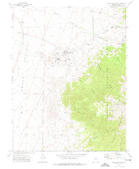
1971 Map of Round Mountain
USGS Topo · Published 1975About this map
Round Mountain sits at the edge of the Big Smoky Valley, defined in the early 1970s by its intensive mining operations and its proximity to the high peaks of the Toiyabe National Forest. The landscape around the actual Round Mtn landmark is heavily marked by industrial activity, featuring numerous Mine Dumps, a specialized Landing Strip, and the Steigmeyer Mill located to the north near Jefferson Creek. This survey captures the town in a period of transition, where the local economy remained tied to the mineral wealth of the surrounding canyons while maintaining essential community landmarks like the local Cem. East of the valley floor, the terrain rises sharply into a series of deeply cut drainages including Ink House Canyon and Slaughterhouse Canyon, providing a detailed look at the water sources and rugged geography of central Nevada.
Find a feature on this map
34 named features on this map. Tap any name to fly to it.
Don’t see what you’re looking for? This feature index may not catch every label — zoom into the map to look around manually.
Map Details
Editions of this 1971 Round Mountain Map
This is the sole edition of this map. No revisions or reprints were ever made.
Other maps of this area

1907 · Tonopah
USGS Topo · 1:250,000

1908 · Tonopah
USGS Topo · 1:250,000

1956 · Tonopah
USGS Topo · 1:250,000

1959 · Tonopah
USGS Topo · 1:250,000

1962 · Tonopah
USGS Topo · 1:250,000

1971 · Carvers
USGS Topo · 1:24,000

1971 · Seyler Peak
USGS Topo · 1:24,000

1971 · Manhattan
USGS Topo · 1:24,000

1971 · Pablo Canyon Ranch
USGS Topo · 1:24,000

1971 · Belmont West
USGS Topo · 1:24,000