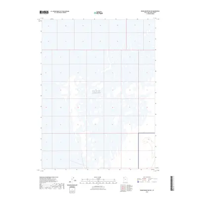
2023 Map of Round Mountain SW
USGS Topo · Published 2023About this map
Utah Test and Training Range occupies a significant portion of this landscape in Box Elder County, showing the specialized military footprint in the Great Salt Lake Desert. The map reveals the stark, geometric layout of the training grounds, punctuated by numerous alkali flats and small, ephemeral desert depressions. This modern topographic survey illustrates the intersection of vast government land reservations and the natural hydrography of the basin floor. While the terrain appears largely uniform, the detailed contour intervals at the map's edge reflect the subtle rise of desert landforms within a highly restricted zone of the American West.
Find a feature on this map
1 named feature on this map. Tap any name to fly to it.
Don’t see what you’re looking for? This feature index may not catch every label — zoom into the map to look around manually.
Map Details
Editions of this 2023 Round Mountain SW Map
This is the sole edition of this map. No revisions or reprints were ever made.
Other maps of this area

1953 · Tooele
USGS Topo · 1:250,000

1954 · Brigham City
USGS Topo · 1:250,000

1955 · Tooele
USGS Topo · 1:250,000

1958 · Brigham City
USGS Topo · 1:250,000

1962 · Brigham City
USGS Topo · 1:250,000

1969 · Hogup Ridge South
USGS Topo · 1:24,000

1973 · Grassy Mountains
USGS Topo · 1:24,000

1973 · Knolls 2 NE
USGS Topo · 1:24,000

1973 · Finger Ridge
USGS Topo · 1:24,000
1979 · Bonneville Salt Flats
USGS Topo · 1:100,000