
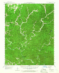
1945 Map of Round Spring
USGS Topo · Published 1962About this map
Round Spring State Park anchors this mid-century topographic record, which captures a landscape defined by its complex karst topography and traditional Ozark industry. The Current River and Jacks Fork meander through the terrain, fed by notable water features like Roaring Spring and the mysterious Devils Well. Rural life in the 1940s is mapped through a network of small schools such as Cedar Hill Sch and South Shady Grove Sch, alongside landmarks like the Shannondale Fire Tower. Historical mills, including Mauser's Mill and Brushy Mill, illustrate the era's water-driven economy. Geologic points of interest like Round Spring Caverns and Cyclops Cave reflect the unique subterranean geography of the region, while the Alton Club and Camp Zoe suggest the area's established role as a destination for outdoor recreation and community gathering.
Find a feature on this map
70 named features on this map. Tap any name to fly to it.
Don’t see what you’re looking for? This feature index may not catch every label — zoom into the map to look around manually.
Map Details
Editions of this 1945 Round Spring Map
2 editions found
Other maps of this area

1915 · Eminence
USGS Topo · 1:62,500

1917 · Eminence
USGS Topo · 1:62,500

1928 · Cardareva
USGS Topo · 1:62,500

1932 · Cedar Grove
USGS Topo · 1:48,000

1941 · Salem
USGS Topo · 1:62,500

1941 · Stone Hill
USGS Topo · 1:62,500

1943 · Boss
USGS Topo · 1:62,500

1944 · Corridon
USGS Topo · 1:62,500

1945 · Salem
USGS Topo · 1:62,500

1945 · Stone Hill
USGS Topo · 1:62,500