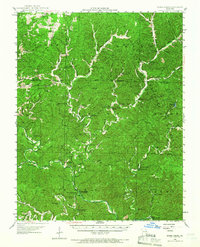
1945 Map of Round Spring
USGS Topo · Published 1966About this map
Current River and Jacks Fork serve as the primary hydrologic features of this Ozark landscape, where the karst topography is revealed through numerous subterranean formations and surface springs. Notable geologic landmarks include Round Spring Caverns, Devils Well, and The Sinks, which define the region's unique drainage patterns. The map documents a mid-century period of rural settlement characterized by small communities like Shannondale and Gladden, and local industry represented by Falk Mill and Mausers Mill. Public lands and recreational sites are well-established, with the Mark Twain National Forest and Round Spring State Park providing a structured boundary to the dispersed homesteads and country schools such as Empire Sch and Wellsford Sch.
Find a feature on this map
77 named features on this map. Tap any name to fly to it.
Don’t see what you’re looking for? This feature index may not catch every label — zoom into the map to look around manually.
Map Details
Editions of this 1945 Round Spring Map
2 editions found

Other maps of this area

1915 · Eminence
USGS Topo · 1:62,500

1917 · Eminence
USGS Topo · 1:62,500

1928 · Cardareva
USGS Topo · 1:62,500

1932 · Cedar Grove
USGS Topo · 1:48,000

1941 · Salem
USGS Topo · 1:62,500

1941 · Stone Hill
USGS Topo · 1:62,500

1943 · Boss
USGS Topo · 1:62,500

1944 · Corridon
USGS Topo · 1:62,500

1945 · Salem
USGS Topo · 1:62,500

1945 · Stone Hill
USGS Topo · 1:62,500