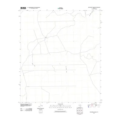
2010 Map of Roundhill Ranch
USGS Topo · Published 2010About this map
Roundhill Ranch serves as the primary landmark in this ranching landscape of Val Verde County. The terrain is defined by a network of drainage channels including Big Fielder Draw in the northeast and the parallel courses of Osman Draw and Little Osman Draw. These intermittent waterways shape the movement of cattle and the placement of local infrastructure in an area where water management is central to the land's utility. Transportation is confined to a sparse grid of rural routes, notably Ranch Rd 1865, Pumpville Rd, and Felder Draw Rd. The presence of these named draws and roads provides a framework for understanding contemporary property boundaries and land use in this part of West Texas during the early 21st century.
Find a feature on this map
7 named features on this map. Tap any name to fly to it.
Don’t see what you’re looking for? This feature index may not catch every label — zoom into the map to look around manually.
Map Details
Editions of this 2010 Roundhill Ranch Map
This is the sole edition of this map. No revisions or reprints were ever made.
Other maps of this area

1943 · Malvado
USGS Topo · 1:62,500

1943 · Langtry
USGS Topo · 1:62,500

1944 · Malvado
USGS Topo · 1:62,500

1954 · Sonora
USGS Topo · 1:250,000

1958 · Sonora
USGS Topo · 1:250,000

1958 · Del Rio
USGS Topo · 1:250,000

1964 · Del Rio
USGS Topo · 1:250,000

1970 · Pandale
USGS Topo · 1:24,000

1970 · Little Fielder Draw
USGS Topo · 1:24,000
1973 · Harkell Canyon
USGS Topo · 1:24,000