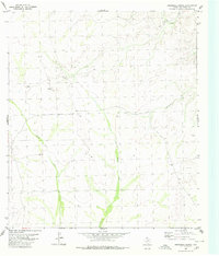
1980 Map of Roundhill Ranch
USGS Topo · Published 1980About this map
Roundhill Ranch serves as a primary landmark in this western Texas landscape, documented during a 1974 topographic survey and edited in 1980. The terrain is defined by a complex network of dry watercourses, most notably the winding paths of Osman Draw and Little Osman Draw. These ephemeral features, along with Big Fielder Draw and Henderson Draw, dictate the movement and settlement patterns of this arid region. The sparse distribution of man-made features like Bassett underscores the remote ranching character of Val Verde County during this period. Small-scale infrastructure, including various labeled tanks and a Well, highlights the critical importance of water management for livestock and survival in the high desert environment of the late twentieth century.
Find a feature on this map
9 named features on this map. Tap any name to fly to it.
Don’t see what you’re looking for? This feature index may not catch every label — zoom into the map to look around manually.
Map Details
Editions of this 1980 Roundhill Ranch Map
This is the sole edition of this map. No revisions or reprints were ever made.
Other maps of this area

1943 · Malvado
USGS Topo · 1:62,500

1943 · Langtry
USGS Topo · 1:62,500

1944 · Malvado
USGS Topo · 1:62,500

1954 · Sonora
USGS Topo · 1:250,000

1958 · Sonora
USGS Topo · 1:250,000

1958 · Del Rio
USGS Topo · 1:250,000

1964 · Del Rio
USGS Topo · 1:250,000

1970 · Pandale
USGS Topo · 1:24,000

1970 · Little Fielder Draw
USGS Topo · 1:24,000
1973 · Harkell Canyon
USGS Topo · 1:24,000