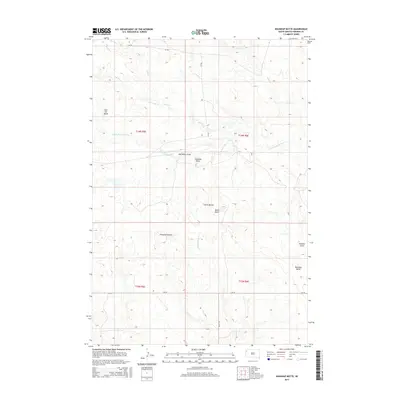
2015 Map of Roundup Butte
USGS Topo · Published 2015About this map
Roundup Butte and the surrounding high plains of Harding County are defined by a network of ephemeral drainage draws and prominent geologic formations. The N Fork Moreau River cuts through the center of the landscape, fed by seasonal watercourses like Second Sand Cr and Soft Water Draw. This area, part of the larger rangelands of South Dakota, shows a distribution of landmarks named for early settlement or geographic features, including the Ferguson Buttes, Davis Buttes, and the isolated East Six Butte. The presence of Stockade Draw hints at the region's historical ranching and frontier legacy. Transportation is limited to section-line routes such as CR-796 and CR-732, illustrating the low-density, wide-open character of this northern prairie environment during the early 21st century.
Find a feature on this map
20 named features on this map. Tap any name to fly to it.
Don’t see what you’re looking for? This feature index may not catch every label — zoom into the map to look around manually.
Map Details
Editions of this 2015 Roundup Butte Map
This is the sole edition of this map. No revisions or reprints were ever made.
Other maps of this area

1935 · Hoover
USGS Topo · 1:125,000

1935 · Harding
USGS Topo · 1:125,000

1954 · Lemmon
USGS Topo · 1:250,000

1957 · Lemmon
USGS Topo · 1:250,000

1973 · Lone Tree Draw East
USGS Topo · 1:24,000

1973 · Lone Tree Draw West
USGS Topo · 1:24,000

1973 · Redig
USGS Topo · 1:24,000
1977 · Granger Creek
USGS Topo · 1:24,000
1978 · Redig NE
USGS Topo · 1:24,000
1978 · Bams Butte NW
USGS Topo · 1:24,000