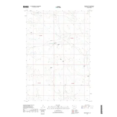
2017 Map of Roundup Butte
USGS Topo · Published 2017About this map
The N Fork Moreau River meanders through this remote portion of Harding County, defining a landscape of high plains drainage and prominent elevation markers. Distinctive landforms such as Davis Buttes, Ferguson Buttes, and the landmark Roundup Butte rise above the surrounding terrain, providing essential navigational points in the open country. The intricate network of seasonal waterways including Duck Cr, Second Sand Cr, and Goose Cr illustrates the erosional patterns of the region. Local transit is limited to a few established routes such as Thompson Rd and Redig Rd, which connect the scattered draws and buttes. This survey preserves the ranching character of the territory, naming specific local features like Soft Water Draw and Stockade Draw that speak to the practical history of land use and water access in the northern plains.
Find a feature on this map
20 named features on this map. Tap any name to fly to it.
Don’t see what you’re looking for? This feature index may not catch every label — zoom into the map to look around manually.
Map Details
Editions of this 2017 Roundup Butte Map
This is the sole edition of this map. No revisions or reprints were ever made.
Other maps of this area

1935 · Hoover
USGS Topo · 1:125,000

1935 · Harding
USGS Topo · 1:125,000

1954 · Lemmon
USGS Topo · 1:250,000

1957 · Lemmon
USGS Topo · 1:250,000

1973 · Lone Tree Draw East
USGS Topo · 1:24,000

1973 · Lone Tree Draw West
USGS Topo · 1:24,000

1973 · Redig
USGS Topo · 1:24,000
1977 · Granger Creek
USGS Topo · 1:24,000
1978 · Redig NE
USGS Topo · 1:24,000
1978 · Bams Butte NW
USGS Topo · 1:24,000