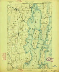
1895 Map of Rouse Point
USGS Topo · Published 1898About this map
Fort Montgomery stands at the northern edge of this late nineteenth-century survey, guarding the critical transition where Lake Champlain narrows into the Richelieu River at the Canadian border. The map illustrates a complex maritime and rail hub centered on Rouse Point, where the Central Vermont R. R. and G. T. R. R. converge to cross the water. The landscape is defined by the deep indentations of King Bay and Monty Bay, with the islands of Isle La Motte and North Hero framing the eastern passages. Smaller settlements like Coopersville and Chazy are linked by the Delaware and Hudson Canal Co. R. R., while the shoreline is dotted with navigational aids like the Isle La Motte L. H. and Point au Roche L. H., reflecting the era's heavy reliance on both lake traffic and international rail commerce.
Find a feature on this map
117 named features on this map. Tap any name to fly to it.
Don’t see what you’re looking for? This feature index may not catch every label — zoom into the map to look around manually.
Map Details
Editions of this 1895 Rouse Point Map
3 editions found
Other maps of this area

1894 · Plattsburg
USGS Topo · 1:62,500

1895 · Mooers
USGS Topo · 1:62,500

1895 · Rouse Point
USGS Topo · 1:62,500

1899 · Mooers
USGS Topo · 1:62,500

1906 · Plattsburg
USGS Topo · 1:62,500

1907 · Rouse Point
USGS Topo · 1:62,500

1913 · Dannemora
USGS Topo · 1:62,500

1913 · Milton
USGS Topo · 1:48,000

1914 · St. Albans
USGS Topo · 1:48,000

1915 · Milton
USGS Topo · 1:62,500