
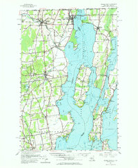
1956 Map of Rouses Point
USGS Topo · Published 1958About this map
Lake Champlain dominates this borderland landscape, serving as a liquid boundary between New York, Vermont, and Quebec. In the mid-1950s, the international and interstate character of the region is defined by infrastructure like the U S Customs station and the Rutland Railroad, which crosses the water at Rouses Point. The map captures a unique topographical mix of island communities and lakeside settlements, including Isle La Motte and Alburg. On the New York shore, the legacy of early defense is visible at the Fort Montgomery (Ruin) near the Richelieu River outlet. Cultural landmarks such as St Anns Shrine and the Miner Institute suggest a landscape deeply rooted in religious tradition and agricultural education. The presence of multiple cemeteries like St Marys Cem and Bush Cem provides essential points of reference for local historians and genealogists tracking the families of Champlain and Beekmantown.
Find a feature on this map
138 named features on this map. Tap any name to fly to it.
Don’t see what you’re looking for? This feature index may not catch every label — zoom into the map to look around manually.
Map Details
Editions of this 1956 Rouses Point Map
2 editions found
Other maps of this area

1894 · Plattsburg
USGS Topo · 1:62,500

1895 · Mooers
USGS Topo · 1:62,500

1895 · Rouse Point
USGS Topo · 1:62,500

1899 · Mooers
USGS Topo · 1:62,500

1906 · Plattsburg
USGS Topo · 1:62,500

1907 · Rouse Point
USGS Topo · 1:62,500

1913 · Dannemora
USGS Topo · 1:62,500

1913 · Milton
USGS Topo · 1:48,000

1914 · St. Albans
USGS Topo · 1:48,000

1915 · Milton
USGS Topo · 1:62,500