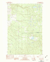
1982 Map of Rousseau
USGS Topo · Published 1983About this map
The Ottawa National Forest dominates this landscape in the western Upper Peninsula, where timber and transport once dictated the pace of life. A distinct Old RR Grade cuts through the forest south of Rousseau, tracing the path of former logging infrastructure that once connected remote settlements like Pori and Dishinaw. The terrain is defined by a dense network of waterways, including the West Branch Firesteel River and numerous creeks such as Hubbell Creek and Newholm Creek, which fed the region's industrial and natural needs. Local history is anchored by a small Cem near the center of the sheet and recreational markers like the Campground and Boat Landing on the shores of Bob Lake. Scattered extraction sites, including a Sand Pit and Borrow Pit, hint at the ongoing utility of the land during the early 1980s.
Find a feature on this map
29 named features on this map. Tap any name to fly to it.
Don’t see what you’re looking for? This feature index may not catch every label — zoom into the map to look around manually.
Map Details
Editions of this 1982 Rousseau Map
This is the sole edition of this map. No revisions or reprints were ever made.
Other maps of this area

1949 · Rockland
USGS Topo · 1:62,500

1950 · Greenland
USGS Topo · 1:62,500

1951 · Rockland
USGS Topo · 1:62,500

1951 · Greenland
USGS Topo · 1:62,500

1954 · Rousseau
USGS Topo · 1:62,500

1954 · Winona
USGS Topo · 1:62,500

1958 · Iron River
USGS Topo · 1:250,000

1960 · Iron River
USGS Topo · 1:250,000

1961 · Iron River
USGS Topo · 1:250,000

1967 · Iron River
USGS Topo · 1:250,000