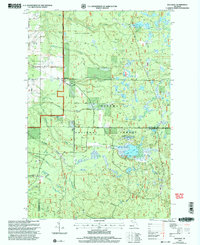
1999 Map of Rousseau
USGS Topo · Published 2004About this map
Ottawa National Forest dominates the landscape of this Upper Peninsula survey, where the small settlements of Rousseau and Pori serve as primary points of human activity. The terrain is defined by an intricate network of waterways, including the West Branch Firesteel River and numerous tributaries such as Dishinaw Creek and Porterfield Creek. A modest Cem near Rousseau and scattered Sandpits indicate a history of local resource extraction and early community life. Recreational use is evident along the North Country National Scenic Trail, which winds through the timbered sections near Bob Lake and Sudden Lake. This late-twentieth-century revision illustrates a region where the logging and forest-management infrastructure of Ranger Road and Pori Road provides the backbone for both industry and wilderness access.
Find a feature on this map
23 named features on this map. Tap any name to fly to it.
Don’t see what you’re looking for? This feature index may not catch every label — zoom into the map to look around manually.
Map Details
Editions of this 1999 Rousseau Map
This is the sole edition of this map. No revisions or reprints were ever made.
Other maps of this area

1949 · Rockland
USGS Topo · 1:62,500

1950 · Greenland
USGS Topo · 1:62,500

1951 · Rockland
USGS Topo · 1:62,500

1951 · Greenland
USGS Topo · 1:62,500

1954 · Rousseau
USGS Topo · 1:62,500

1954 · Winona
USGS Topo · 1:62,500

1958 · Iron River
USGS Topo · 1:250,000

1960 · Iron River
USGS Topo · 1:250,000

1961 · Iron River
USGS Topo · 1:250,000

1967 · Iron River
USGS Topo · 1:250,000