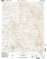
2004 Map of Rover Peak
USGS Topo · Published 2006About this map
Tonto National Forest lands dominate this high-desert landscape along the Yavapai and Maricopa County border. Settlement is sparse, represented by remote outposts like Holmes and 51 Ranch, while the legacy of early 20th-century extraction is centered at the Red Rover Mine near the southern boundary. The distribution of water sources is critical to this terrain, with dozens of named tanks and springs—including Indian Ruin Tank, Lime Cabin Spring, and Jack Brooks Spring—supporting both ranching operations and local wildlife. Topographical landmarks such as Rover Peak, Sunset Mountain, and Magazine Mesa provide prominent navigational points throughout the quadrangle. The map also documents numerous prospects and specialized survey markers like Uslm 2746, indicating the area's history of mineral exploration and land management within the forest reserve.
Find a feature on this map
68 named features on this map. Tap any name to fly to it.
Don’t see what you’re looking for? This feature index may not catch every label — zoom into the map to look around manually.
Map Details
Editions of this 2004 Rover Peak Map
This is the sole edition of this map. No revisions or reprints were ever made.
Other maps of this area

1887 · Verde
USGS Topo · 1:250,000

1892 · Verde
USGS Topo · 1:250,000

1929 · Turret Peak
USGS Topo · 1:125,000

1930 · Cave Creek
USGS Topo · 1:125,000

1933 · Turret Peak
USGS Topo · 1:125,000

1939 · Cave Creek
USGS Topo · 1:125,000

1954 · Holbrook
USGS Topo · 1:250,000

1954 · Mesa
USGS Topo · 1:250,000

1957 · Mesa
USGS Topo · 1:250,000

1957 · Holbrook
USGS Topo · 1:250,000