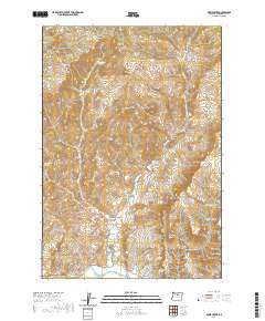
2020 Map of Rowe Creek
USGS Topo · Published 2020About this map
John Day River flows along the southern edge of this Wheeler County landscape, marking the low point of a territory defined by deep canyons and prominent volcanic buttes. Modern access is primarily facilitated by Rowe Creek Rd, which follows the drainage through the center of the map toward the Rowe Cr Reservoir. The topography reveals a history of land use and habitation through family-named features and sites of early industry, such as Old Mill Canyon and the Lambing Camp Canyon. Numerous water sources are scattered throughout the higher elevations, including Mathieson Spring, Homestead Spring, and Alkali Spring, which were essential for ranching and homesteading in this arid environment. The map also features significant landmarks like Red Rock and Sugarloaf Mtn, providing clear reference points for those studying the geology or land grants of the region.
Find a feature on this map
51 named features on this map. Tap any name to fly to it.
Don’t see what you’re looking for? This feature index may not catch every label — zoom into the map to look around manually.
Map Details
Editions of this 2020 Rowe Creek Map
This is the sole edition of this map. No revisions or reprints were ever made.
Other maps of this area

1926 · Mitchell
USGS Topo · 1:125,000

1955 · Bend
USGS Topo · 1:250,000

1957 · Bend
USGS Topo · 1:250,000

1958 · Bend
USGS Topo · 1:250,000

1966 · Mitchell
USGS Topo · 1:62,500

1966 · Kinzua
USGS Topo · 1:62,500

1966 · Clarno
USGS Topo · 1:62,500

1968 · Painted Hills
USGS Topo · 1:24,000

1981 · Stephenson Mountain
USGS Topo · 1:100,000
1987 · Rowe Creek
USGS Topo · 1:24,000