
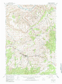
1966 Map of Mitchell
USGS Topo · Published 1968About this map
Mitchell stands as a central point of settlement in this Central Oregon landscape, surrounded by a dramatic sequence of geologic buttes including Bailey Butte, Marshall Butte, and Scott Butte. The northern reaches of the quadrangle are defined by the winding path of the John Day River, which flows near the small community of Twickenham. This 1960s survey illustrates a region where livestock and ranching infrastructure predominate, noted by the presence of the Shoofly Ranch and Old Frizzell Ranch. Local history is anchored by landmarks such as the Richmond Cemetery and the Gable Creek School, alongside a Wheeler BM Historical Marker that signals the area's early surveying roots. The southern portion of the map transitions into the Ochogo National Forest, where the terrain climbs toward peaks like White Butte and Juniper Butte.
Find a feature on this map
64 named features on this map. Tap any name to fly to it.
Don’t see what you’re looking for? This feature index may not catch every label — zoom into the map to look around manually.
Map Details
Editions of this 1966 Mitchell Map
2 editions found
Other maps of this area

1926 · Mitchell
USGS Topo · 1:125,000

1932 · Dayville
USGS Topo · 1:125,000

1936 · Dayville
USGS Topo · 1:125,000

1951 · Lookout Mtn
USGS Topo · 1:62,500

1953 · Richmond
USGS Topo · 1:62,500

1953 · Spray
USGS Topo · 1:62,500

1955 · Bend
USGS Topo · 1:250,000

1955 · Canyon City
USGS Topo · 1:250,000

1957 · Bend
USGS Topo · 1:250,000

1958 · Bend
USGS Topo · 1:250,000