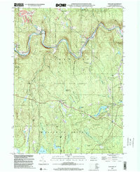
1999 Map of Rowland
USGS Topo · Published 2001About this map
The Lackawaxen River winds through this corner of Pike County, shaping a landscape defined by deep river bends and conservation lands. The late-twentieth-century topography shows a territory largely preserved within Delaware State Forest and various state game lands, yet punctuated by long-established settlements. Along the northern rail corridor, landmarks like Shimers Rock Cut and Glen Eyre speak to the area's industrial transit history. Moving south into the plateau, small communities such as Germantown and Greeley are surrounded by an intricate network of wetlands, including Smithsko Swamp and Little Mud Pond Swamp. Local genealogy is anchored by sites like Mt Moriah Cem near Kimble and the Pillar of Fire Ch, providing essential touchstones for family historians tracing the inhabitants of these wooded uplands and creek valleys.
Find a feature on this map
55 named features on this map. Tap any name to fly to it.
Don’t see what you’re looking for? This feature index may not catch every label — zoom into the map to look around manually.
Map Details
Editions of this 1999 Rowland Map
This is the sole edition of this map. No revisions or reprints were ever made.
Other maps of this area

1913 · Milford
USGS Topo · 1:62,500

1915 · Milford
USGS Topo · 1:62,500

1920 · Damascus
USGS Topo · 1:62,500

1922 · White Lake
USGS Topo · 1:62,500

1923 · Damascus
USGS Topo · 1:62,500

1935 · Hawley
USGS Topo · 1:62,500

1938 · Hawley
USGS Topo · 1:62,500

1942 · White Lake
USGS Topo · 1:62,500

1943 · Honesdale
USGS Topo · 1:125,000

1943 · White Lake
USGS Topo · 1:62,500
Featured Places
- Lackawaxen Township, PA
- Blooming Grove Township, PA
- Baoba, Lackawaxen Township
- Rowland, Lackawaxen Township
- Camelot Forest, Blooming Grove Township