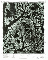
1976 Map of Rowland
USGS Topo · Published 1978About this map
Rowland serves as the central hub of this mid-1970s orthophotoquad, showing the town's grid and residential layout in stark contrast to the surrounding agricultural landscape. This aerial perspective, captured in early 1976, reveals the intricate drainage patterns and densely wooded creek beds that weave between expansive, irregularly shaped farm fields. Small rural communities and intersections like Alfordsville and Oakland Crossroads are visible as clusters of structures along the primary road network, providing a clear view of the rural settlement patterns in Robeson County during this era. Further north, the settlement of Purvis sits along the rail line, illustrating the historical connection between transportation corridors and local development. The orthophoto format provides a literal visual record of land use, from the precise rows of crops to the dense vegetation lining the regional waterways.
Find a feature on this map
4 named features on this map. Tap any name to fly to it.
Don’t see what you’re looking for? This feature index may not catch every label — zoom into the map to look around manually.
Map Details
Editions of this 1976 Rowland Map
This is the sole edition of this map. No revisions or reprints were ever made.
Other maps of this area

1943 · Pages Mill
USGS Topo · 1:62,500

1953 · Florence
USGS Topo · 1:250,000

1954 · Florence
USGS Topo · 1:250,000

1960 · Dillon East
USGS Topo · 1:24,000

1960 · Dillon West
USGS Topo · 1:24,000

1962 · Gaddysville
USGS Topo · 1:24,000

1962 · Fair Bluff
USGS Topo · 1:62,500

1971 · Minturn
USGS Topo · 1:24,000

1971 · Johns
USGS Topo · 1:24,000

1972 · Pembroke
USGS Topo · 1:24,000