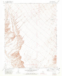
1969 Map of Rox SE
USGS Topo · Published 1982About this map
Meadow Valley Wash defines the southwestern drainage patterns of this arid landscape, situated along the historic boundary between Lincoln and Clark counties. The topography is marked by deep alluvial fans and dissecting drainages like Whitmore Wash and Weiser Wash, which trend southeast toward the lower basins. A solitary Jeep Trail navigates the northern reaches of the quadrangle, indicating the minimal infrastructure present in this part of southern Nevada during the late 1960s. This survey records a transition from high desert plateaus to complex wash systems, providing a clear picture of the natural drainage corridors used by early travelers and surveyors.
Find a feature on this map
5 named features on this map. Tap any name to fly to it.
Don’t see what you’re looking for? This feature index may not catch every label — zoom into the map to look around manually.
Map Details
Editions of this 1969 Rox SE Map
2 editions found
Other maps of this area

1886 · Saint Thomas
USGS Topo · 1:250,000

1893 · Saint Thomas
USGS Topo · 1:250,000

1954 · Las Vegas
USGS Topo · 1:250,000

1957 · Las Vegas
USGS Topo · 1:250,000

1958 · Moapa
USGS Topo · 1:62,500

1958 · Overton
USGS Topo · 1:62,500

1959 · Las Vegas
USGS Topo · 1:250,000

1962 · Las Vegas
USGS Topo · 1:250,000

1969 · Farrier
USGS Topo · 1:24,000
1969 · Rox
USGS Topo · 1:24,000