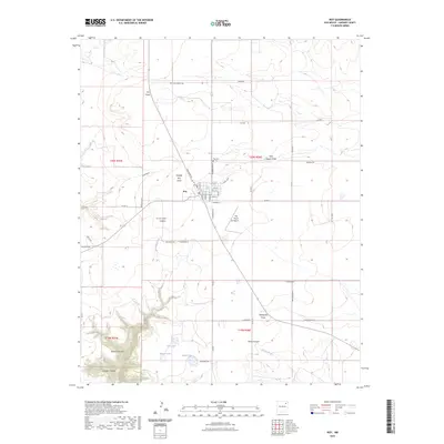
2023 Map of Roy
USGS Topo · Published 2023About this map
Roy serves as the central hub of this northeastern New Mexico landscape, situated at the junction of several county roads and defined by its grid of residential streets including Church St and Floersheim St. The surrounding high plains are cut by complex drainage patterns, with Matilda Roy Draw and La Cinta Creek carving through the terrain toward deeper depressions like La Cinta Canyon. To the north, the Roy Cem sits along the road to the John Snyder Draw, while the Ray Ranch Airport provides a modern aerial connection to this traditional ranching country.
Find a feature on this map
52 named features on this map. Tap any name to fly to it.
Don’t see what you’re looking for? This feature index may not catch every label — zoom into the map to look around manually.
Map Details
Editions of this 2023 Roy Map
This is the sole edition of this map. No revisions or reprints were ever made.
Other maps of this area

1954 · Santa Fe
USGS Topo · 1:250,000

1954 · Raton
USGS Topo · 1:250,000

1958 · Raton
USGS Topo · 1:250,000

1958 · Santa Fe
USGS Topo · 1:250,000

1971 · Beaver Canyon
USGS Topo · 1:24,000

1971 · Canon Encierro
USGS Topo · 1:24,000

1972 · Mills West
USGS Topo · 1:24,000
1974 · Roy
USGS Topo · 1:24,000
1974 · Kansas Valley
USGS Topo · 1:24,000
1974 · Kansas Valley Lake
USGS Topo · 1:24,000