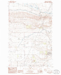
1986 Map of Royal City
USGS Topo · Published 1986About this map
Royal City stands as the primary hub on the Royal Slope in this mid-1980s look at Grant County's agricultural interior. The landscape is defined by the sophisticated Columbia Basin Project irrigation works, most notably the West Canal and the Royal Branch Canal which feed the local farming economy. Between the high ridges of the Frenchman Hills to the north and Crab Creek to the south, the map reveals a meticulously managed environment.
Find a feature on this map
21 named features on this map. Tap any name to fly to it.
Don’t see what you’re looking for? This feature index may not catch every label — zoom into the map to look around manually.
Map Details
Editions of this 1986 Royal City Map
This is the sole edition of this map. No revisions or reprints were ever made.
Other maps of this area

1909 · Quincy
USGS Topo · 1:62,500

1910 · Quincy
USGS Topo · 1:62,500

1910 · Winchester
USGS Topo · 1:62,500

1911 · Red Rock
USGS Topo · 1:62,500

1912 · Beverly
USGS Topo · 1:62,500

1950 · Smyrna
USGS Topo · 1:62,500

1951 · Smyrna
USGS Topo · 1:62,500

1953 · Walla Walla
USGS Topo · 1:250,000

1953 · Ritzville
USGS Topo · 1:250,000

1954 · Beverly NE
USGS Topo · 1:24,000