
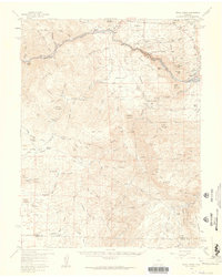
1959 Map of Royal Gorge
USGS Topo · Published 1961About this map
The Grand Canyon of the Arkansas River and the famous Royal Gorge dominate this landscape, illustrating a period where tourism and heavy infrastructure converged in the high country. The Denver & Rio Grande Western RR follows the river's path, supported by the Parkdale Siding, while a Miniature RR serves the immediate park area. Beyond the canyon walls, the map documents the transition from early mining and ranching to institutional land use, including the State Penitentiary and the YMCA Mountain. Genealogists and local historians can locate specific homesteads and former settlements such as Griffin Ranch, Payne Ranch, and the Yorkville site. The complex drainage system, defined by dozens of named gulches like Copper Gulch and Sawmill Gulch, reveals how the terrain dictated the layout of Sunset City and the access routes into the San Isabel National Forest.
Find a feature on this map
95 named features on this map. Tap any name to fly to it.
Don’t see what you’re looking for? This feature index may not catch every label — zoom into the map to look around manually.
Map Details
Editions of this 1959 Royal Gorge Map
3 editions found
Other maps of this area

1889 · Canon City
USGS Topo · 1:125,000

1892 · Canon City
USGS Topo · 1:125,000

1894 · Pikes Peak
USGS Topo · 1:125,000

1901 · Pikes Peak
USGS Topo · 1:125,000

1942 · Cover Mtn.
USGS Topo · 1:62,500

1948 · Cover Mtn.
USGS Topo · 1:62,500

1954 · Cooper Mountain
USGS Topo · 1:24,000

1954 · Mount Tyndall
USGS Topo · 1:24,000

1954 · Pueblo
USGS Topo · 1:250,000

1955 · Westcliffe
USGS Topo · 1:24,000