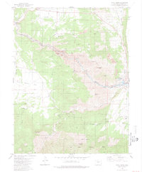
1980 Map of Royal Gorge
USGS Topo · Published 1981About this map
Canon City anchors the eastern edge of this Colorado landscape, where the Arkansas River carves deep into the granite to form the Royal Gorge. This 1980 survey captures the infrastructure supporting both industry and tourism at the canyon's edge, including the winding Skyline Drive and the Denver and Rio Grande Western Railroad tracks following the riverbed. The map details the developed Royal Gorge Park area, complete with a Miniature RR and various picnic areas, while the northern high ground of Eightmile Park is marked by numerous quarries and the settlement of Buckskin Joe. To the south, the terrain becomes increasingly complex around Temple Canyon Park and the slopes of YMCA Mountain, illustrating the intricate drainage systems of Grape Creek and various gulches that feed into the central river corridor.
Find a feature on this map
46 named features on this map. Tap any name to fly to it.
Don’t see what you’re looking for? This feature index may not catch every label — zoom into the map to look around manually.
Map Details
Editions of this 1980 Royal Gorge Map
3 editions found
Other maps of this area

1889 · Canon City
USGS Topo · 1:125,000

1892 · Canon City
USGS Topo · 1:125,000

1894 · Pikes Peak
USGS Topo · 1:125,000

1901 · Pikes Peak
USGS Topo · 1:125,000

1942 · Cover Mtn.
USGS Topo · 1:62,500

1948 · Cover Mtn.
USGS Topo · 1:62,500

1954 · Cooper Mountain
USGS Topo · 1:24,000

1954 · Pueblo
USGS Topo · 1:250,000

1957 · Pueblo
USGS Topo · 1:250,000

1958 · Pueblo
USGS Topo · 1:250,000