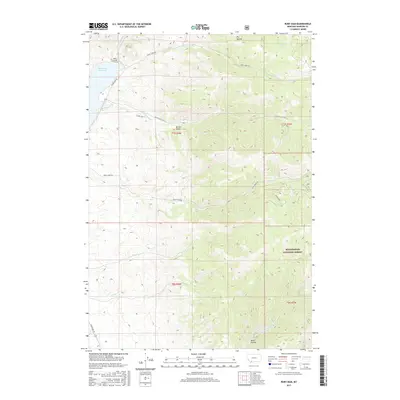
2017 Map of Ruby Dam
USGS Topo · Published 2017About this map
Ruby Dam stands at the northwestern edge of this landscape, holding back the Ruby River Reservoir as the Ruby River flows north through Madison County. The terrain is defined by a series of steep drainages including Davey Cr, Idaho Cr, and Jack Cr, which cut through the high country of the Beaverhead National Forest. This 2017 survey captures a remote ranching and forest environment where access is maintained via unpaved routes like Upper Ruby Rd and Barton Gulch Rd. Local landmarks like Metzel Ranch and the small settlement at Barton Gulch reflect the sparse human imprint on these highlands. From the depths of Dark Hollow to the upper reaches of N Fork Greenhorn Cr, the map illustrates a network of seasonal streams and ridgelines that characterize this portion of southwestern Montana.
Find a feature on this map
23 named features on this map. Tap any name to fly to it.
Don’t see what you’re looking for? This feature index may not catch every label — zoom into the map to look around manually.
Map Details
Editions of this 2017 Ruby Dam Map
This is the sole edition of this map. No revisions or reprints were ever made.
Other maps of this area

1888 · Three Forks
USGS Topo · 1:250,000

1893 · Dillon
USGS Topo · 1:250,000

1894 · Three Forks
USGS Topo · 1:250,000

1895 · Three Forks
USGS Topo · 1:250,000

1947 · Bozeman
USGS Topo · 1:250,000

1948 · Bozeman
USGS Topo · 1:250,000

1949 · Varney
USGS Topo · 1:62,500

1950 · Virginia City
USGS Topo · 1:62,500

1955 · Bozeman
USGS Topo · 1:250,000

1955 · Dillon
USGS Topo · 1:250,000